First Major Winter Storm of the Season Hits All But Extreme Southern New England
Wind Advisory In Effect from 4 PM - 7 PM for Most of Massachusetts
Winter Storm Warning Remains in Effect for Much of NH and Maine.

Snowfall predictions as of Saturday afternoon superimposed with storm totals as of this morning. Click to enlarge.
 Regional map of storm totals. It's not all done quite yet.
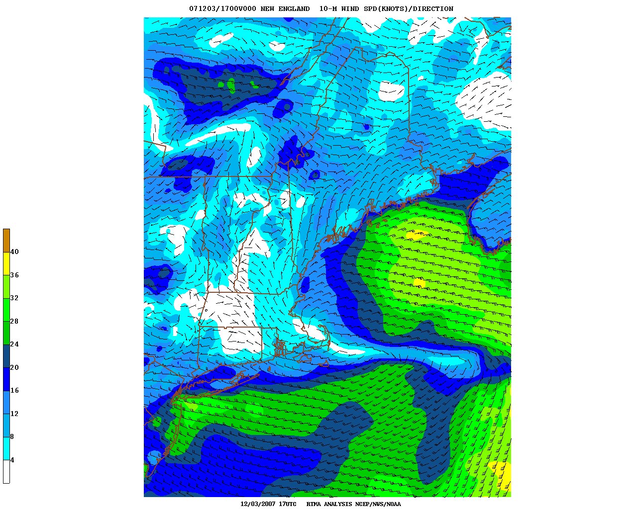 Surface wind field off the Massachusetts coast. The storm is currently gaining strength to the east of Cape Cod - where the winds are lighter (light blue). If you look closely, you can see the counterclockwise rotation around the currently elongated low.
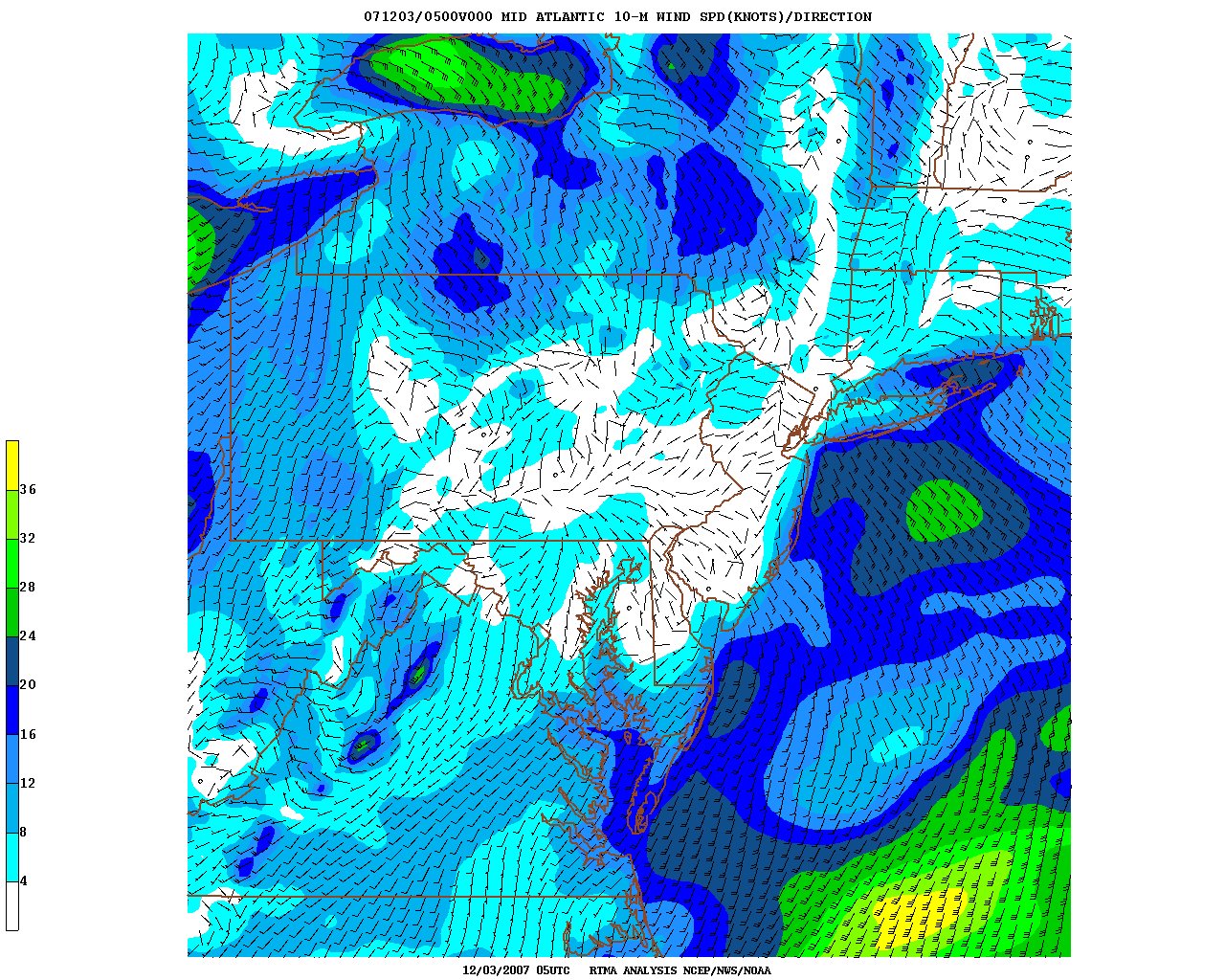 Wind field over New York and Pennsylvania. I put this in because the winds here are from the WEST over northern New York state, while they are from the North over much of Southern New England. Where these wind fields converge, we could see some enhanced snowfall this afternoon.
 Current visible satellite. The black dot to the east of the Cape is the center of the surface low. Not exactly an "eye", but worth noting.
 Current local radar shows precipitation blossoming on the backside of the storm.
 Earlier regional radar. The echoes have filled in the last couple hours as the storm deeepens off the coast. Because of the low-level convergence over our area, we could see a decent band of snow this afternoon with an additional 1-3" on snow-covered surfaces.
 Enhanced infared imagery showing the center of the storm (the light blue circular area) located to the east of Cape Cod.
 Well, our winter is off to a fun start! Dec. 1st marks the first day of meteorological winter, and we aren't that far off the mark with our first snowstorm! Last night, precipitation in Massachusetts ran the gamet from snow to sleet to freezing rain. Lowell was JUST on the northern fringe of the snow line for much of the event, giving us accumulations right around the 4" mark as of this morning.
As the storm intensifies off Cape Cod this afternoon and heads into the Gulf of Maine, we will see additional accumulating snows on the backside of the storm, on the order of 1-3 inches. We normally don't see much snow on the "backlash" of the storm, however, the parent storm currently located over the Great Lakes is still relatively strong, and low level winds are from the west over upper New York State. As this air flow collides with the northerly winds from the developing storm off the coast, we will likely see a decent band of moderate snows this afternoon in Essex and Middlesex counties, which will likely add another 1-3" to our current storm totals.
Winds will start to crank this afternoon as the low strengthens, and we could see gusts up to 40 mph. So hang on to your hats!
The storm is expected to move SLOWLY through the Gulf of Maine through tomorrow, keeping clouds and windy conditions through the area, although the accumulating snows should be over by this evening.
The rest of the week looks to remain on the wintry side, with colder than normal temperatures, mostly cloudy conditions, and a slight chance for snow Wednesday and Friday.
And now on to the forecast.
Rest of today: Wind advisory in effct this afternoon. Cloudy with snow accumulating an addition 1-3". Becoming windy. Temperatures slowly falling through the upper 20s. NW winds 10-20 mph, with gusts up to 40 mph possible this evening.
Tonight: Cloudy and windy early, with a chance of light snow showers. Little additional accumulation. Lows near 24.
Tuesday: Mostly cloudy and continued cold. Chance of a morning flurry. High 34.
Tuesday night: Mostly cloudy. Low 20.
Wednesday: Mostly cloudy with the chance of a snow shower. High near 33.
Extended Outlook
Thursday: Here comes the sun! Mostly sunny, high 34.
Friday: Mostly cloudy. Slight chance of light snow. High near 36.
For WUML 91.5 Fm this is WUML weather director and UMass Lowell student meteorologist John Webster.

No comments:
Post a Comment