Dust Off Your Snow Shovels !
Wintry Mess Monday Morning to be Bookended by Periods of Accumulating Snow
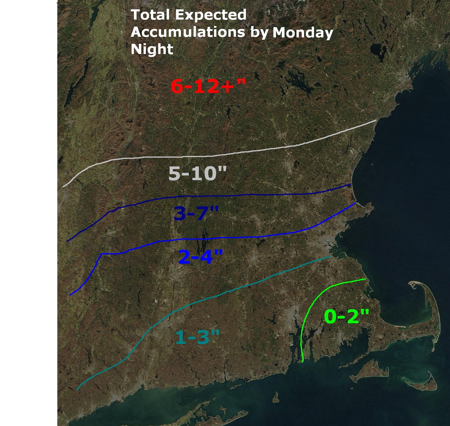 Current thinking of total snow and ice accumulations by Monday NIGHT.
 Satellite view of the storm, currently located over the upper Midwest.
 Computer model projection for 7 am Monday, showing the secondary storm just starting to form near Cape Cod. Note the dashed red line, showing warmer air at mid-levels spreading into southern Massachusetts. This warmer mid-level air should change the snow over to a mix of snow and sleet early Monday, cutting down on potential accumulations.
 As the storm deepens and pulls away Monday, cold air will rush back into Massachusetts, and any mixed precipitation will change back over to snow. We could see 1-3 inches from this backlash, making Lowell totals in the 4-7 inch range.
 Weather map for Monday morning.
 This storm will have a decent amount of moisture to work with. Liquid precipitation totals are pictured above. If this storm were all snow, we could be looking at 10-15 inches.....but that is highly unlikely.
Ahh, the exciting Saturday nights of a meteorolgy senior... no, I'm not meeting up with friends at the local bar for a good time - I'm at home, making a REALLY strong cup(s) of coffee, and settling in for a night of homework and studying after working from 9am-4pm. Since we have an important storm coming up, I figured I might as well throw my two cents in with an important update!
Computer models haven't changed all that much from yesterday... they did a little colder-warmer-colder see-saw, of which I didn't feel like jumping on the bandwagon, despite some of the larger media outlets doing so. That being said, I am raising total expected storm accumulations by a smidge - right now it looks like the Lowell area will see 4-7 " by the time all is said and done.
I do want to point out that the total accumulations above are as of Monday night. We will have 2 bursts of accumulating snows - 1 Sunday night to start the storm, after which it will likely change to a mix of snow, sleet, and possibly rain by early Monday morning, after which it will change back to snow as the storm pulls away.
We could see 2-4" of accumulation for the first part of the storm, and another 1-3 in the storm's backlash Monday afternoon. Needless to say, Monday looks pretty messy for these parts.
By Monday night, we are left with lingering clouds and possibly some light snow/flurries, but the heavy stuff will be long gone. However, winds will start to crank Monday afternoon, and that will last through much of Monday night.
If you check out the snowfall graphic at the top, there is a rather tight gradient between 2-4" and 6-12". If you shift everything 50 miles north or south, that will lead to some pretty different snowfall tallies. Being that it is Saturday night, and the storm isn't forecast to wind down until Monday night, these amounts will likely need to be tweaked as we get closer to the start of the storm. Barring no surprises though, I think the above is a pretty good estimate given the current data.
For whatever reason, the National Weather Service has chosen NOT to issue a winter storm watch for our area - most likely because storm totals over 6" are not a guarantee for Lowell (6" or more being the threshold for a winter storm warning). However, as new model data comes in, that could change. If I were in charge, I would have issued a watch for our area. But I'm not. In any event, we'll keep you posted.
In the meantime, arctic air will make for a frigid night tonight. Temperatures fell through the 20s for most of the day today, and coupled with the wind-chill, it felt like it was in the single digits and teens out there. Tonight will be no exception.
Tonight: Bitterly cold! Increasing high cloudiness. Low 7. Wind chills near zero!
Sunday: Clouds lowering and thickening throughout the day. Furries possible late afternoon. steady light snow breaks out between 8 pm and midnight. High 31.
Sunday Night: Light snow becoming steadier and heavier. Snow will likely mix with sleet and possibly freezing rain after 3 AM. Low 32.
Monday: AM Mess! Snow/sleet/rain mix early, changing back to all snow by mid-morning or early afternoon. Additional light accumulations possible. High 36. East winds becoming North at 10-15 mph, with gusts up to 35 mph possible late.
Monday Night: Cloudy, with light snow or flurries possibly early. Little if any additional accumulation expected. Cold and windy, with lows near 22.
Tuesday: Mostly cloudy. Chance of a flurry. High 33.
Wednesday : Partly cloudy. Highs in the lower 30s.
Thursday: Mostly cloudy with a chance of snow showers. Highs in the lower 30s.
For WUML Lowell 91.5 FM this is WUML weather director and UMass Lowell student meteorologist John Webster. Make sure to check back tomorrow for an important update!

No comments:
Post a Comment