Friday, November 30, 2007

Wintry Mess Likely for Sunday Night and Monday

Exact Storm Track to Determine Precipitation Type
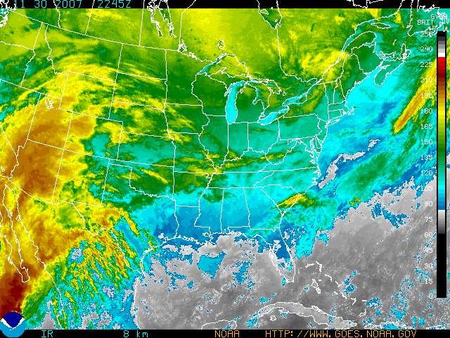
Current enhanced infared satellite view. The storm which will begin to affect us Sunday night is currently taking shape out west, as evidenced by the higher cloud tops in yellow and orange. Click to enlarge.

Before the storm pays us a visit, it will be impacting much of the country. This is the season's first major winter storm event for the United States. Detailed model analysis, showing various computer model projections for the path and location of Monday's storm. The different colors represent different forecast times, and the many symbols indicate where different computer models put the center of the low pressure system for each timeframe. Click to enlarge.
If the last graphic was confusing, this one should be better. Simplified projection on the location and path of the storm system traversing the country which will affect us Sunday night and Monday. Note the dot to the southeast of Long Island, indicating where the secondary coastal low is now forecast to develop. Click to enlarge.
Total precipitation for the upcoming storm could exceed 1.25 "of liquid water equivalent.... If it were ALL snow, that would be about a foot!


Temperatures will take the plunge the next couple days, as arctic air begins to move south out of Canada. A cold front passing the region this evening will make sure of that.


Although the weather Saturday will be quiet - the proverbial "calm before the storm," it will get downright FRIGID tomorrow night. Overnight lows will be just above 10 degrees, so make sure to bundle up if you plan on hitting the town tomorrow night.


All this cold air sets the stage for Sunday and Monday. A low pressure system will approach us from the west on Sunday, and will be located over the Great Lakes by Sunday evening. Snow will likely begin to overspread the area in advance of the approaching system sometime early Sunday night.


By early Monday morning, a secondary coastal storm will begin to spin up in the Atlantic. Yesterday, model consensus was that this storm would form near Cape Cod, and track northeastward into the Gulf of Maine, intensifying as it moved away. Today, computer models have begun to shift the low pressure formation further south and west, just off the coast of Long Island. Refer to the graphics above for a good indication of where the storm looks to get going.


What does this mean for us? It could indicate that the colder air may be tougher to scour out than originally thought, and it could provide us with more moisture as the storm's dry slot will not form over the region.


However, east winds off the warmer waters of the Atlantic will be a big player in this system. Right now, it does appear that warmer air will work into the middle layers of the atmosphere for a decent portion of the storm, which would mean we would see a mixed bag of snow, sleet, freezing rain, and rain - especially late Sunday night and early Monday.


By Monday afternoon, the precipitation could change to all snow as colder air wraps into the system from the north. However, the precipitation will be starting to wind down at this point, so I expect light accumulations from the backlash.


The big question everyone wants to know is HOW MUCH WILL WE GET?
Keep in mind that this event won't be over until Monday night, and its only Friday, so we are still a ways out. My best guess at this point would be 2-4 inches of heavy, sloppy, wet snow/sleet accumulating through Monday night. You know, the cement-like stuff that's oh-so-fun to shovel....


However, one of the computer models has been keeping the system further south, and our area colder for the storm. If this scenario verifies, our totals could be more in the 4-8" range. I think it's too early to make that prediction just now, but if the models start to converge on a colder solution tomorrow, accumulations may need to be increased for the Lowell area.


Make sure to check back tomorrow for an all important update. And now here's the forecast......

Lowell Regional Forecast

Tonight: Mostly clear and cold. Low 24.


Saturday: Mostly sunny and cold. High near 31. Gusty NW winds at 10-20 mph will make it feel like it's upper teens to low 20's.


Saturday Night: Clear and Frigid. Lows near 12.


Sunday: Clear to start, becoming mostly cloudy by afternoon. High 33.


Sunday Night: Cloudy, with light snow possible by evening. Precipitation will become steadier and heavier during the overnight. Snow may mix with and change to sleet and rain, especially towards morning. Low 26.


Monday: Morning communte could be a mess. Mixed bag of wet snow, sleet, and rain during the morning, ending as a period of light snow during the afternoon. High 35.


Tuesday: Partly cloudy. High 34.


For WUML Lowell 91.5 Fm, this is WUML weather director and student meteorologist John Webster urging you to check back for an important update tomorrow.


Have a great weekend everyone!

Thursday, November 29, 2007

VERY TRICKY FORECAST FOR POTENTIAL WEEKEND STORM


Click here to go directly to today's forecast!


Living in New England is one of the most challenging, and interesting, places to live if you are in the business of forecasting the weather. Let's face it - we have it all.....springtime rains/floods, summer heat waves and thunderstorms, an occasional tropical system, and finally winter storms.

Winter storms are one of the most difficult weather features to forecast. Not only do we need to worry about storm intensity, but we obsess over the potential track of the storm. Why all this scrutiny? It all boils down to precipitation type - a shift in the storm track of 50 miles can make the difference between a rainstorm and a whopper of a snowstorm. To complicate matters, a storm track shift of 50 miles is a drop in the bucket when attempting to forecast from several days in advance.

Well, now that we have THAT out of the way, let's talk about how things look to play out at this stage in the game. We saw a cold front move through New England today accompanied by some scattered showers. Temperatures will be cooler by tomorrow, and downright cold by Saturday as arctic air begins to spill south out of Canada. In the meantime, a storm will start to organize out west over the 4-corners region by tomorrow night, and start heading into the Plains. Keep in mind, this system hasn't even formed yet.

As the storm moves northeast, it will be located over the eastern Great Lakes by late Sunday. Now comes the tricky part.

Computer models have been flopping like presidential candidates in the hot seat the last couple days... the main questions being if a secondary storm will develop over the Atlantic, where does it develop, and how intense does it get? I can say with confidence that we will see a secondary storm develop, however the details of exactly where and how quickly it intensifies are still up in the air.Check out one of the models below to see the latest thinking on where the secondary storm will start to spin up.

Computer model prediction for 7 AM Monday morning, with a secondary storm beginning to form very close to Cape Cod. Click to enlarge.
Computer model prediction for 1 PM Monday, showing most of the precipitation to our north by this time. Click to enlarge.

Ahead of the main low pressure over the Great Lakes, moisture will spread east in advance of the system, and we will likely see light snow overspread the area by late Sunday afternoon or evening.

As the secondary coastal low starts to form Sunday night, the energy from the primary storm will transfer to the coast. The new low pressure system will begin to intensify rapidly as it moves north.

However, current thinking is that the secondary low will form very near Cape Cod, and not get stronger until it is north of us in the Gulf of Maine. What does this mean for us? Right now, it looks like the heavy snows will fall in northern New England, and not in our neck of the woods. Warmer air will likely infiltrate the region from the Atlantic with winds being due east with the storm position near Cape Cod.

So, to sum it up, we probably start as light snow Sunday evening, mix with sleet and rain late Sunday night/early Monday, and then switch over to just plain old rain during the day on Monday. We could see the precipitation end as some light snow or flurries as the storm blows up east of Maine, and drags down colder air via strong northerly winds.

Below is a graphic based on the latest computer models depicting the most likely result of the Sunday/Monday event.


Tentative prediction for track of the upcoming storm, with a weak Low forming near Cape Cod and intensifying in the Gulf of Maine. To the north of the white line, all snow is likely from the event, with heavy amounts possible in ski country and Down east Maine. Between the green and white line, mixing appears likely with light snow accumulations possible. To the south, a quick period of snow to start followed by mostly rain is the best guess at this time.

Pretty far in advance, but this could be your wakin'-up-weather for next Monday. Again, conditions could be very different at that time depending on the actual track of the storm.


Now, I must issue this caveat - this storm is still over 3 days away, and much can change during that time-frame. As of now, it looks like Lowell may get a slushy 1-3 inches of snow before the change over to rain late Sunday night/early Monday. HOWEVER - if the storm forms further southeast and intensifies more rapidly, we could be looking at a colder, snowier scenario. If it is weaker and further north, we would be looking at more of a rain event.

Check back for important updates. The WUML weather team will be tracking the progress of the system closely. Details will become clearer as we draw closer to Sunday.

And now for the forecast......


Lowell Regional Forecast

Tonight: Partly cloudy and brisk. Low 26. West winds 10-15 mph, with gusts up to 25 mph.

Friday: Mostly sunny and breezy. Cooler, with highs near 42. NW winds 10-15 mph, with gusts up to 25 mph possible through early afternoon.

Friday Night: Partly cloudy. Low 23.

Saturday: Bundle up! Mostly sunny, windy, and seasonably cold. High 33. NW winds around 15 mph, with gusts up to 30 mph possible.

Sunday: Increasing cloudiness, with light snow possible after dark. High 33.

Sunday Night: Light snow mixing with sleet and rain, changing to all rain by early morning. Low near 29.

Monday: Morning rain tapering off by mid-afternoon. The precipitation could end as light snow or flurries. High 40.

Tuesday: Partly cloudy. Highs in the upper 30s.

For WUML Lowell 91.5 FM this is WUML weather director and UMass Lowell student meteorologist John Webster. Make sure to check back tomorrow for an important update!

Wednesday, November 28, 2007

Relatively Quiet Weather Through The Workweek...
Watching A Potentially Important Storm For Sunday and Monday

National high temperatures for today. Click to enlarge.


National high temperatures for Saturday. Note how much colder the northern tier of the United States will be compared to today. Click to enlarge.

Current visible satellite imagery for the East Coast. Click to enlarge.


Current enhanced infared satellite imagery for the East Coast, showing low clouds in light blue and higher clouds in yellow. Click to enlarge.

Average high temperatures this time of year are right around 45 degrees. So far today in Lowell, we have managed to make it just up to the 40 degree mark, with some high cloudiness helping to keep things cooler by filtering out some of the sunlight. These high clouds are associated with a weak area of low pressure near the Great Lakes which will be visiting us for tomorrow.

By tomorrow, the weak system passing well to our north will give us the chance of some scattered morning flurries, and as the day warms up, temperatures would become too warm to support any snow, so we run the risk of a quick shower or two through Thursday afternoon. This little storm does have an accompanying cold front with it, which means things will start to cool down quite a bit for the weekend. Most of the weekend looks to remain on the dry side, but by Sunday, a potent storm system looks to get going over the middle of the country and track to our NW over the Great Lakes.

Cold air + strong storm.... sounds like things could get interesting, huh? And they could. However, with a storm passing to our west, this means warm air will flow up from the South into our region as the storm passes by. This happens because storms spin counterclockwise. If the storm were forecast to pass to our east, then we would be in for a big snowstorm as the cold air would drain down from the north, keeping temperatures at or below freezing for most of the event.

As it looks now, we could be dealing with a mixed bag of precipitation, starting out as snow Sunday evening and changing to sleet, freezing rain, and then to plain old rain by midday Monday.

I am often asked how does sleet and freezing rain form. Check out the diagram below - it nicely illustrates the concept. Snow occurs when a thin layer of warm, moist air rides over a deep cold layer of air. However, the thicker the layer of warm air, the greater the chances that the snow will melt on its way down. Why then, don't we just get plain old rain?

If there is a layer of cold air at the surface, the rain will re-freeze on the way down. This looks like it could be the case for the weekend storm, as we will have cold dense air at the surface, with warmer air aloft sliding over it. As more warm air moves in, the precipitation will transition from snow, to sleet, and then to freezing rain, and finally to plain rain. Tired of reading my explanation? Check it out graphically below....


Graphical representation of vertical temperatures and expected precipitation type, which could be a factor by late Sunday and Monday. Click to enlarge.


Computer model showing the forecast location of the upcoming storm as of 7 PM Sunday night. The storm is forecast to be strong, but to pass well to our west and north.

To the north of the blue line, temperatures will be below freezing at the surface, which is important in forecasting precipitation type. Note that this blue line will be very close to Lowell, making for a tricky forecast. Click to enlarge.

So by Sunday evening, things could be getting pretty tricky around here. A few things should be noted:

1. This storm is several days away, and computer models aren't always accurate from several days out.

2. Any change in the storm track will change the forecast.

3. If the storm re-develops near the coast, we will have a colder, snowier scenario.

4. How much cold air will be entrenched in the region by Sunday?

5. Timing. Does most of the precipitation fall during the colder night-time hours, or during the day on Monday?

There are more subtle variables at play such as "bagginess" in the low, and if the storm moves closer to us but remains west, stronger SW flow may scour out the colder air more quickly. I won't go into everything because my job is to attempt to forecast and educate - not to bore!

We will be tracking the upcoming weekend storm and will have an update tomorrow. Again, this does not appear to be a big snow maker, but with frozen precipitation possible, conditions could become tricky late Sunday and Sunday night. We should have a much better picture of the event by Friday and especially Saturday.

Whew! Well, if you made it this far, you deserve the detailed forecast. And here it is.....


Lowell Regional Forecast

Rest of Today: Sunshine filtered through high clouds. High near 40.

Tonight: Clouds lowering and thickening. Chance of a flurry late. Low 27.

Thursday: Cloudy with a morning snow shower possible, followed by a chance for rain showers in the afternoon. Warmer, with a high near 45.

Thursday Night: Decreasing cloudiness. Low 27.

Friday: Partly cloudy and cooler. High 41.

Saturday: Mostly sunny and seasonably cool. High 35.

Sunday: Becoming mostly cloudy. Chance of light snow and sleet by afternoon. High 33.

Monday: Cloudy with a wintry mix or rain possible early, becoming all rain by afternoon. High 41.

For WUML Lowell 91.5 FM this is WUML weather director and UMass Lowell student meteorologist John Webster.

Tuesday, November 27, 2007

Return to Chilly Weather

Tomorrow's weather map. Click to enlarge.

Today was a wacky weather day. Lowell's high of 59 degrees was recorded not this afternoon..... but early this morning!In addition, nearby Bedford was 62 degrees at 2 am! But once the cold front slid by, temperatures started taking a tumble, despite the warmth of the sunshine throughout the latter half of the day. Most of us ended up in the mid 40s by early afternoon.... Wave goodbye to those fleeting 60s!

Now our pattern is on the chillier side, and temperatures will reflect that over the next few days. However, the next couple days won't be all that bad. The weekend is once again looking cold, with temperatures struggling to reach the low 30s.

By late Sunday and early Monday, a strong storm system may approach the region. Earlier models were hinting at a whopper of a snowstorm.... now they are giving us a dousing of rain as the storm passes to the west and keeps us in a warm SW flow. What will really happen? Check back for updates. We'll be tracking the development of this system throughout the week.

Newest computer models indicate that next Monday may be a rainy one. Click to enlarge.

And now for the detailed forecast......

Tonight: Clear and much colder. Low near 29. West winds 5-10 mph.

Wednesday: Mostly sunny. High 45. North winds 5-10 mph could be gusty in the afternoon.

Wednesday Night: Becoming mostly cloudy. Flurries possible toward dawn. Low 26.

Thursday: Cloudy with a chance of rain showers. Highs in the upper 40s.

Friday: Partly Cloudy and cooler. High 42.

Extended Outlook

Saturday: Mostly sunny and cold. High 32.

Sunday: Increasing cloudiness throughout the day. Chance of light snow or rain toward evening. Heavier precipitation possible during the overnight. High 33.

For WUML 91.5 FM this is WUML weather director and UMass Lowell student meteorologist John Webster.

Monday, November 26, 2007

Another Rainy Day in the Northeast!


Hello everyone! I hope you all had a wonderful thanksgiving break; and I hope you all survived the Black Friday shopping frenzy. After seeing the movie "Jingle All the Way" with Arnold Schwarzenegger ; I've pretty much sworn to myself I would never leave the house before a certain hour to do any kind of shopping. on that day


So far today we've had approximately 0.23 inches of rainfall. We're expecting a little over half of an inch of rain by tomorrow. Things are expected to dry up by Wednesday as a high pressure system drifts into the area.


Tomorrow's Rainfall:


We are currently in the midst of a low pressure system that should continue into tomorrow morning. We are expecting a cold front to also accompany this system. By Wednesday a high pressure system will fall into place. Looking ahead into Thursday through Saturday; we'll experience some cold fronts. there is also a possibility for another low pressure system to develop and affect us by Sunday.


Today: showers, patchty fog. Visibility under a quarter mile. Highs in the 40s. Light and variable winds.
Tonight: showers and dense fog. Heavy rainfall is possibile. Lows in mid 40s. 5-10 mph winds increasing 15-25 mph with gusts up to 35 mph.

Tuesday: cloudy with a chance of am showers. Becoming mostly sunny in the afternoon. Highs in the upper 50s. 15-20 mph winds. gusts up to 30 mph.
Tuesday night: mostly clear with a low around 30.

Wednesday: Sunny. Highs in the mid 40s. Winds from the west at 10-15 mph.
Wednesday night: Mostly cloudy with lows in the mid 30s.

Thursday: Rain showers. Highs in the upper 40s.
Thursday night: mostly clear lows in the lower 30s.

Friday: Mostly sunny. Highs in the mid 40s.
Friday night: Mostly cloudy with lows in the mid 20s.

Saturday: mostly sunny and cooler. Highs near 40.
Saturday night: Mostly clear. Lows in the lower 20s.


Sunday: Partly sunny. Highs in the upper 30s.

Well that's a look at your weather for the rest of the week, this is student meteorologist Lucie Rawlins signing off!

Sunday, November 25, 2007

Rainy Monday and Monday Night

Weather map for Monday at 7pm. Click to enlarge

An area of low pressure will be affecting the region through Tuesday, with the bulk of it falling as rain during the day tomorrow and tomorrow night. However, as the warm, moist air associated with the storm system flows over the colder air at the surface, we could see the precipitation start off as some freezing rain. Right now, it does not appear that Lowell will experience any freezing precipitation, as we should be just above the 32 F degree mark. Check out the map below for current thinking on where the frozen stuff will fall.

Lowell will be on the border between freezing rain and just plain rain tonight. Be cautious if out traveling, especially North and West of the city. A FREEZING RAIN ADVISORY has been issued for areas just to our west, so be alert out there on the roads. Read the entire advisory here: http://forecast.weather.gov/wwamap/wwatxtget.php?cwa=box&wwa=freezing%20rain%20advisory

By tomorrow morning (9-10am) most of Massachusetts should be just plain rain as surface temperatures warm above freezing. However, it doesn't stop there. Computer models have been spitting out large amounts of rain for the region through Tuesday - in some cases over 2 inches! Yikes! Needless to say, the rain will be heavy at times Monday and Monday night before tapering off Tuesday morning. Below is some of the computer models used in making storm total forecasts..... High resolution model forecasting storm totals for the upcoming event. Click to enlarge.
Another high resolution model. Click to enlarge.

The whole rainy mess it outta here by Tuesday night, but with the rain goes the warm temperatures, and things will chill off here by the middle of next week, with "chilly" meaning a close to average 45 degrees by Wednesday. Next up, we will be watching an Alberta Clipper, which could swing through here around Thursday with some light snow or rain. Check back for updates as we get closer to the event.

And now for the detailed forecast.....


Lowell Regional Forecast

Tonight: Becoming mostly cloudy with rain possible toward dawn. The rain may start off as a brief period of freezing rain. Low 32.

Monday: Cloudy with rain likely. High 47. Light southerly winds.

Monday Night: Cloudy with rain, heavy at times. Temperatures slowly climbing through the upper 40s. Southwest wind 15-20 mph, with gusts up to 30 mph late.

Tuesday: Cloudy to start, followed by clearing. Mild, with a high of 54.

Wednesday: Partly cloudy and cooler. High 45.

Thursday: Mostly cloudy with a chance of light rain or snow. High 46.

Friday: Cloudy to start, becoming mostly sunny by midday. High 44.

For WUML 91.5 FM this is WUML Weather Director and UMass Lowell student meteorolgist John Webster.


Friday, November 23, 2007

Chilly Friday and Saturday... Followed By A Warm-Up

Click here to go directly to today's forecast!

Today's weather map. Click to enlarge.


Bitterly Cold Temperatures Tonight!

After a damp and mild Thanksgiving, weather conditions are much different across the region today. Cold air from Canada is pouring into Southern New England riding on some gusty winds from the NW. Today's cool temperatures coupled with winds gusting up to 30 mph means that, yup, it's time to break out the Wind Chill Index. Check it out below - click to enlarge. What will the apparent temperature feel like today with highs near 40F and winds at 30 mph? See if you can figure it out.......


If you guessed wind chills of 28F, I better look out because you might be after my job. It will definitely feel chilly today. Tonight will be even colder, with lows bottoming out around 15 degrees and winds at 5-10 mph. What does that spell out for us? Wind chills of 3-7F tonight! Now THAT is scarf and glove weather......

Did you know that the National Weather Service changed the wind chill index back in 2001? Well, now you do! The change was made based on new computer information and advancements in apparent temperature modelling techniques. What's an apparent temperature? It's the temperature that your body feels when you factor in temperature and the wind, which helps to blow away the invisible layer of heat we have surrounding our bodies. Below is a comparison between the new wind chill and the old one. They have, in fact, lowered the severity of the wind chill effect. But it's still important, and will become even more so as we transition into the colder winter months.


So, do we have any SNOW to go along with the bitterly cold windchills forecasted for tonight? Nope. Conditions will remain dry for us through the weekend, with our next storm approaching Monday afternoon and lasting through Tuesday morning. By then temperatures will be much warmer. I expect upper 40s to lower 50s, meaning we get wet - not white. Computer models are cranking out a decent amount of precipitation with this one though, so we could see some heavier showers as the storm moves through Monday night.

Rain totals could exceed 1 inch for parts of the area for the storm next Monday/Tuesday.

And now, let's get to the detailed forecast. Enjoy the holiday weekend!


Lowell Regional Forecast

Today: Mostly sunny and much cooler. High near 40. NW winds 10-15 mph, with gusts up to 30 mph. Wind chills in the 20s.

Tonight: Clear and COLD. Low 14. NW winds at 5-10 mph will make it feel like its in the single digits outside!

Saturday: Sunny and cold. High 38.

Saturday Night: Another cold one. Clear with lows near 15.

Sunday: Mostly sunny and warmer. High 47.

Monday: Sunny to start with increasing clouds during the afternoon. Chance of rain by evening. Rain could be heavy at times durnig the overnight. High 48.

Tuesday: Mostly cloudy with morning showers possible. High 54.

For WUML Lowell 91.5 FM this is WUML weather director and UMass Lowell student meteorologist John Webster.

Thursday, November 22, 2007

Warm, Foggy Conditions Helping Turkeys On The Run!


Click here to go directly to today's forecast!

National temperature map with my own nifty graphics superimposed. The Low pressure system currently located over New York State/Pennsylvania will bring us a quick shot of warm air before things turn colder for Friday.
Warm weather and the cover provided by foggy conditions have aided these turkeys who made a daring escape from the purdue farm 3 days ago. They were last spotted in Boston trying to catch a train north. Word is they're headed to Canada for political asylum....

Other, less fortunate birds, have resorted to more creative techniques!


Simulated radar imagery for 7 PM this evening shows a line of showers approaching the region from the west, associated with a strong cold front.


Forecast highs for Massachusetts today will be in the upper 50s to low 60s!
Current New England Temperatures as of 10 AM.
Mid-Atlantic temperatures as of 10 AM. This warm air will be headed our way for the afternoon before a drastic cool down tomorrow.

Happy Thanksgiving!


Well, I couldn't resist having a little Thanksgiving fun with the blog this morning. That gang of turkeys does look pretty intimidating though....haha!


This morning finds much of New England socked in with dense fog and visibilities 1 mile or less. Some places have visibilities less than 1/4 of a mile. What's with all the fog? Warmer air is trying to overspread the area and scour out the cooler marine layer currently in place at the surface. This is creating an inversion, or temperatures increasing with height. With a stagnant atmospheric profile like this, the low clouds, fog, and drizzle aren't going anywhere through early afternoon. Please use extra caution when driving as visibilities are low enough to make the trip to grandma's dangerous in some areas.


However, that will change this afternoon as a low pressure system over Pennsylvania/New York State will slide just to our North. First, warmer air will begin to mix down from aloft, and temperatures could shoot up to the lower 60s this afternoon. Great weather for turkeys on the run.....


However, this small storm also has a strong cold front associated with it, which will be swinging through the region during the overnight. Ahead of the front, we will see a small line of showers forming, probably some time between 7 and 10 pm, as indicated by one of the models above. Don't get too concerned though - not much rain is expected.


By tomorrow, we have a different weather scenario - cold, windy, and dry conditions will be the norm across the area. Coupled with wind chills, it will feel like its in the 20s to near 30 for most of the day. That means if you'll be hitting the stores at 4 or 5 am, bundle up!

The remainder of the weekend looks to remain on the cool side, with temperatures beginning to warm a bit by Sunday. We'll be watching a storm approaching the region for the Monday/Monday night time frame, although this one looks to be all rain. If the storm tracks further south and east however, we could see some of the white stuff. Check back for updates.


I hope everyone enjoys a Happy Thanksgiving! Gobble Gobble!!


Thanksgiving Day: Morning fog and drizzle slowly burning off by afternoon. Becoming breezy and much warmer. Highs near 60! Calm winds early, with SW winds at 10 mph with gusts to 25 mph this afternoon.


Tonight: Cloudy with a shower possible, especially between 7 and 10 pm. Clearing towards morning. Low 32. WNW busy at 10 mph, with gusts to 25 mph.


Friday: Mostly clear, but blustery and much colder. Highs in the upper 30s to near 40. NW winds 10-20 mph, with gusts up to 30 mph. Wind chills in the 20s!


Friday Night: Clear and COLD! Lows near 15.


Saturday: Continued Cold. Mostly sunny, with a high of 38.


Sunday: Mostly sunny and a touch warmer. High 44.


Monday: Sunny to start, increasing cloudiness by afternoon. Rain possible by evening. High 46.


Tuesday: Cloudy with a chance of rain. High 43.


For WUML 91.5 FM this is WUML weather director and UMass student meteorologist John Webster. Have a great holiday!

Wednesday, November 21, 2007

Hang On To Your Turkey - Temperature Rollercoaster On The Way!


Click here to go directly to today's forecast!


If Tom Turkey is lucky, he won't be on a platter surrounded by your relatives tomorrow.... he'll be strutting around enjoying temperatures near 60!

Today's Weather Map. Click to enlarge.

Satellite view for Wednesday 11.21. Click to enlarge.


Happy Thanksgiving!


Today was cool, damp, and dreary. We can do better, right? Although we don't have a sunny day on tap for the big Thanksgiving holiday, we can offer up some thanks for the warmth which will be joining us along with the extra helpings of turkey, stuffing, and... roasted beets! Haha. That one is an inside joke.


In all seriousness, tomorrow will feel like a completely different season. We will see temperatures at least in the upper 50s, and if we can scour out the marine layer that is currently giving us lots of fog, drizzle, and low cloudiness, we could be in for some 60s!


But, just like a turkey fresh out of the oven, it's not going to last for very long. If you look at the national map up above, a storm system currently located over the Plains and Great Lakes will be tracking to our north on Turkey-Day, and its associated cold front will swing through by evening. Computer models are not churning out much precipitation with this front, so it doesn't look to be a wet one. It will, however, bring a sharp temperature drop. If you are just crazy enough to go shopping on Black Friday, dress accordingly.... and if you find any really good deals, feel free to pick me up something - because not only do I hate shopping with crowds, but I am on a budget!


The weekend, as previously advertised, will remain on the cold side, helping to usher in the unofficial start of the Christmas season accordingly. Is there really an official start to Christmas anyways? If so, let me know....


Looking ahead, a storm system will begin its approach to Southern New England Monday evening, with the main impacts to be felt during the overnight and on Tuesday. Right now this one looks to be all rain.... but it is a few days away and things can change. It could start out as a quick rain/snow mix if it starts during the overnight on Monday. The WUML Weather Team will be monitoring the situation throughout the week and will have future updates for you. Well, I have some stuffing to make for tomorrow! Let's get to the forecast.....


Lowell Regional Forecast

Tonight: Cloudy with patchy fog, some of which could be dense. Spotty drizzle. Low 39.


Thanksgiving Day: Gobble Gobble! Mostly cloudy but WARM. Breezy too. SW winds 5-10 mph, with gusts up to 20 mph.


Thanksgiving Night: Cold front swings through during the evening. Early clouds followed by clearing and a gusty WNW wind. Lows near 35.


"Black Friday": Partly cloudy and colder. High 39. Wind chills in the upper 20s for most of the day.


Saturday: Mostly Sunny and continued cold. High 38.


Sunday: Clear to start, with increasing cloudiness throughout the day. A tad warmer, with highs near 44.


Monday: Mostly cloudy, with rain or rain mixed with snow possible during the overnight. High 45.


For WUML 91.5 FM, this is WUML Weather Director and UMass Lowell student meteorologist John Webster wishing everyone a happy and thankful Thanksgiving, with extra helpings for all!

Tuesday, November 20, 2007

First Widespread Snowfall Blankets Massachusetts

Parts of the Bay State saw up to 2 inches of snow today, the first widespread snowfall of the season.

Forecast national high temperatures for tomorrow. Click to enlarge.


Forecast national weather for tomorrow. Click to enlarge.

SNOW!


Some parts of New England saw up to 2 inches from today's storm, although in Lowell accumulations were closer to half an inch. Roads were slick for a time this afternoon, but warming temperatures and some help from the DPW crews took care of that problem. For more storm totals, follow the link here: http://www.erh.noaa.gov/box/productDisplay.php?product=BOSPNSBOX&version=0


Nothing too exciting on the horizon weather-wise this week - which is good news, especially if you plan on travelling these next couple days. Check the images above for a national weather outlook.


Around these parts, tomorrow will remain on the cloudy side although it will be a little warmer. Good news though - no storms. By Thursday, today's snow will seem like a distant memory, with Turkey Day highs topping out in the mid 50s! Gobble Gobble!


Enjoy it while it lasts, because a cold front will be passing through Thursday Night with some showers, and by Friday highs will be right around 40 again. Our recent trend of a warm midweek followed by a cold weekend looks to continue, so don't put away those heavy coats.


And now for the forecast:


Tonight: Cloudy and cool. Patchy fog/drizzle possible. Low 28.


Wednesday: Continued Mostly cloudy. Spot shower possible in the afternoon. High 44.


Wednesday Night: Cloudy with showers possible. Low 40.


Thanksgiving Day: Mostly cloudy and much warmer. Showers possible toward evening. Highs near 56.


Friday: AM clouds followed by rapid clearing. Much cooler, with a high of 41.


Extended Outlook


Saturday: Even chillier. Sunny but cold. High 38.


Sunday: Mostly sunny. High 44.

Sunday, November 18, 2007

Moderating Temperatures By Midweek
But First..... Snow?

Click here to go directly to today's forecast!
Today's weather map. Click to enlarge.

Can you believe it's already that time of year again? Yup, Thanksgiving week is here. As it looks right now, there won't be any flies in the ointment travel-wise this week... at least in the Northeast. Chilly weekend temperatures will begin to moderate by Wednesday as a warm front approaches from the west. Turkey Day looks to be cloudy and mild with showers possible as colder air drains in behind a storm system passing to our north.

But let's not get ahead of ourselves. We could see some flakes around these parts early tomorrow morning. No, it's not from a storm system, but rather ocean effect snow. As a weak disturbance slides off the coast to our south (which is currently giving Pennsylvania its first widespread snow of the season), it will help to spawn an ocean storm in the Atlantic. Uh-oh! Well, not so fast. This storm won't be impacting our region.... but rather, the pressure gradient between the storm to our southeast and an area of high pressure to our north will give us northeast winds over the warmer Atlantic. This NE fetch may pick up some moisture and deposit it as snow along NE Massachusetts, especially close to the coast. We'll be keeping an eye on this possibility through the overnight.

After a possible brush with the white stuff tomorrow, Tuesday will remain cool and cloudy with a leftover sprinkle/flurry possible early, followed by the aforementioned warm-up on Wednesday. As it stands right now, no travel or airport delays anticipated, aside from those long security check points that us meteorologists can't take the blame for!

Hurricane/Cyclone Sidr Update:

So far, 2,000 have been confirmed dead from last week's category 4 storm that slammed into Bangladesh. That death toll could rise up to 10,000. Hundreds of Thousands of people have been displaced from the storm, with many now homeless. Read up on it here: http://www.cnn.com/2007/WORLD/asiapcf/11/18/bangladesh.cyclone/index.html

And now for the forecast.

Lowell Regional Forecast


Tonight: High thin clouds, lowering and thickening towards morning. Chance of flurries late. Low 27.

Monday: Cloudy with a chance of light snow/flurries early. Light rain showers possible midday. High 40. Little snow accumulation expected.

Monday Night: Mostly cloudy. A lingering flurry possible. Low 28.

Tuesday: Mostly cloudy. High near 41.

Tuesday Night: Cloudy and not as cool. Low 35.

Wednesday: Partly cloudy and warmer. High 52.

Extended Outlook

Thanksgiving Day: Mostly cloudy with showers possible. High 47.

(Black) Friday: Morning clouds followed by afternoon clearing. Highs in the upper 40s.

For WUML Lowell 91.5 FM this is WUML weather director and UMass Lowell student meteorologist John Webster.

Friday, November 16, 2007

Chilly Weekend In Store

Click here to go directly to today's forecast!


Satellite imagery as of 5 PM. The storm currently located over Northern Maine is intensifying as it moves away. In its wake, we have had gusty WNW winds all day. Click to enlarge.

Water Vapor Image showing the amount of moisture in the middle section of the atmosphere. The orange area circled above shows very dry air behind the cold front, which extends all the way from Canada to the Carribbean! Click to enlarge.

While we have been dealing with cold and wind, Bangladesh and India were hit by strong category 4 hurricane Sidr late Thursday, packing winds of 150 mph with gusts up to 184! That's stronger than hurricane Katrina was at landfall. Thousands are homeless after the storm, and the death toll could be high. Read more about it here: http://www.cnn.com/2007/WORLD/asiapcf/11/15/bangladesh.cyclone/index.html


Trivia:


What do they call a hurricane in Bangladesh? Read on for the answer.....

If you weren't happy walking around today with the cold temperatures and windy conditions, and you weren't too thrilled with yesterday's rain, don't blame me. Scroll back up top, find the big "L" on the maps, and start shaking your finger at it. There's your culprit.


A storm which developed along the cold front which passed through yesterday is responsible for the large temperature swing from the lower 60s to the lower 40s. It could be worse though - parts of Maine have been seeing.... yup, the white stuff! Heavy snow/winter storm warnings have been issued for NW Maine, northern New Hampshire, and parts of Vermont.


So with that in mind, we lucked out with this one. Behind the storm, temperatures will remain below normal through the weekend. A small disturbance will slide south of the area Saturday Night, and could bring with it a scattered flurry at most. However, parts of the Cape could see more in the way of snow as the Ocean Effect will be kicking in. What the heck is the Ocean Effect you say? When cold air passes over the warmer waters of the Atlantic, it picks up moisture and spits it out as snow. NE winds Saturday night and early Sunday could do just that over the Cape.


But for us, it looks relatively quiet. Weekend temperatures will stay cool, and by Monday we could be looking at upper 30s/low 40s for a high! however, we could start to see a warm-up around these parts by Wednesday. What about Turkey Day? It's pretty far out, but right now Thanksgiving Day looks to be warmer with showers possible as a cold front approaches from the west. We'll have updates as the big day gets closer.


Trivia Answer:


Hurricanes are called "Cyclones" in the Indian Ocean. While we call any general storm system a cyclone in the United States, in that part of the world the term Cyclone is reserved for the hefty tropical ones. If you were to jet over to the Pacific, a hurricane would be called a "Typhoon!"


And now for the forecast.......


Lowell Regional Forecast

Tonight: Clearing and cool. West winds at 20 mph gusting to 30 mph, diminsishing to 10 mph late. Low 27.

Saturday: Clear to start, becoming partly cloudy during the afternoon. High 44. West winds 10-15 mph.

Saturday Night: Cloudy with a flurry possible. Low 26.

Sunday: Becoming partly sunny. High 43.

Sunday Night: Mostly clear and cold. Low 19.

Monday: Mostly sunny. High 40.

Extended Outlook

Tuesday: Continued mostly sunny. High near 44.

Wednesday: Becoming mostly cloudy. Warmer, with highs in the lower 50s.

Thanksgiving Day: Cloudy with a shower possible. High in the upper 40s to near 50.


For WUML Lowell 91.5 FM, this is WUML weather director and UMass Lowell student meteorologist John Webster. Have a great weekend!

Thursday, November 15, 2007

Click here to go directly to todays forecast!

As my colleague John mentioned at 4:52am, there is a wind advisory in effect from noon today until 4pm. To reiterate – Lowell will be on the side of the strong winds, so little to no damage should occur, we will still, however, feel some winds in the afternoon.
As you can see from this map, the tan area represents the parts of Mass that currently have a hazardous weather advisory, and the darker tan is a winter weather advisory.


Wind Advisories!!!!!

This one shows the wind outlook for 1pm in New England, the brighter colors show the higher forecasted winds for this afternoon.


Temperatures are falling!!!!!


This map actually shows tomorrows temperatures for around 4PM, but I wanted to illustrate that while today and yesterday have been fairly warm for November, the temperatures will be dropping into the 40’s.


And onto the forecast!
Forecast
Today: Cloudy all day, with rain likely in the afternoon. Temperatures will be in the high 50’s, and possibly moving into the low 60’s as the day wears on. This evening will bring more clouds, with the rain lessening overnight. Temperatures will drop into the mid to low 40’s.

Friday: Partly cloudy, with a slight chance of rain showers in the morning, but anything we see for rain should be cleared up in by the afternoon. Temperatures will only be reaching the mid 40’s. Friday night is partly cloudy, and temperatures will be in the low 30’s, maybe even reaching a low of 29 overnight.

Saturday: Partly cloudy, temperatures in the low 40’s.

Sunday: Partly cloudy, temperatures in the high 30’s to end your weekend!

For WUML 91.5 FM this is UMass Lowell student meteorologist Johnna Infanti.