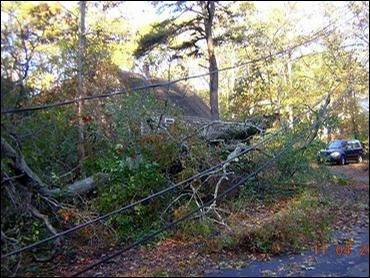
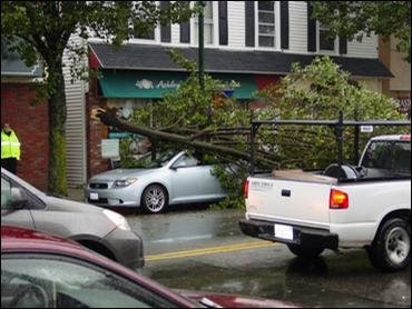
 Trees and branches were snapped by Noel's winds Saturday, which gusted over 90 mph over parts of the Cape and Islands. (photo courtesy WBZ)
 The high winds brought down trees and power lines, leaving many without power in SE Massachusetts. (Photo courtesy WBZ)
 Heavy rains, gusty winds, and flooded roadways, and trees on top of cars made traveling difficult in some parts of the state yesterday. (photo courtesy WBZ)
For even more storm pictures courtesy of WCVB, follow this link:
http://www.thebostonchannel.com/slideshow/weather/14503270/detail.html
Goodbye Noel!
Yesterday afternoon in Lowell just seemed like another typical New England storm - rainy, a little windy, and a bit of an inconvenience. Sustained winds from the storm averaged 15-25 mph, with an occaisional gust up to 35 mph. The worst I saw from the storm here was some ponding on the roadways..... Nothing to write home about.
However, just south of Boston, things were a very different story. Peak wind gusts were in the 60 mph range over SE Massachusetts, with the highest wind gust of 91 mph being reported at 6:31 pm at the Cape Wind Tower located in Horseshoe Shoal. Bet you're glad we didn't see any of that here!
Nantucket was particularly hard hit, bearing the brunt of sustained winds in excess of 50 mph for several hours, with gusts frequently over 70. Over 4" of rain drenched parts of the Cape. Some homes suffered damage due to beach erosion, and unsecured boats were either washed ashore or sunk during Noel's visit yesterday.
Although I can safely say that Lowell lucked out, being just west of the area of damaging winds, it was a bit of a letdown for this severe weather enthusiast. On a positive note, little cleanup is needed in our area after the storm, and hopefully everyone weathered the event safely.
Turning our attention away from Noel, our weather over the next few days looks to be much more on the tame side, with no further tropical influences in sight.
Today should feature partly cloudy skies and seasonable conditions in the wake of Noel, but a small low pressure system is set to glide towards New England and will throw some cloudiness our way for Monday. Monday night and especially Tuesday could be a bit on the rainy side, although I am not expecting any sort of heavy rain event. The system's accompanying cold front will swing through the region by early Wednesday morning, and we could see the season's first flakes as the showers could end as light flurries.
Wednesday and Thursday we will be imbetween systems, and computer models for Friday indicate that a small storm may try to form off the coast. We'll be keeping an eye on this one. Right now it appears we will have a period of light rain, although some of the projections are hinting that we could see a little snow mixed in - but due to climatology I'm not expecting anything eventful. If this changes, we will be sure to let you know.
Looking WAY far out, we could be in for a stormier pattern over the next couple weeks, as long-range models keep an active jet stream near New England, allowing for the storm track to slide through our vicinity. This is very far out, but something to keep in mind. As always, the Umass Lowell/WUML weather team will be tracking any potential storms as they approach.
And now on to the detailed forecast.......
Lowell Regional Forecast
Today: Partly cloudy and milder. High near 56. Winds from the West at 5-10 mph.
Tonight: Becoming mostly cloudy. Low near 35.
Monday: Mostly cloudy. High 55.
Monday Night: Cloudy with showers likely, especially towards morning. Low 44.
Tuesday: Morning showers followed by afternoon cloudiness. Highs near 53.
Tuesday Night: Any leftover showers could end as a period of light flurries. Clearing towards morning. Low 32.
Extended Outlook:
Wednesday: Becoming mostly sunny. A touch cooler, with highs in the upper 40s.
Thursday: Continued sunny, with highs in the upper 40s.
Friday: Watching the possibility of a small storm affecting the area. Mostly cloudy, with a chance of light rain. Some flakes could mix in during the overnight. Highs in the mid 40s.
For WUML 91.5 FM this is Umass student meteorologist and WUML weather director John Webster. Don't forget to turn the clocks back!

No comments:
Post a Comment